Sunday, October 21, 2012

Rockin' Out

Hello everybody. Today is our last day in Bishop. We've learned a lot the last few days. We looked at volcanic deposits, earthquakes, and stream discharge rates. Here are some pictures.

We spent half a day driving and studying an assortment of features in the area. We stopped at the Owens River.


Izzy wearing both of our cowboy hats.


The next day, we made a stratigraphic column of the Bishop Tuff, volcanic pumice deposits.


Izzy measuring the tuff.


Artsy upside down pic.


The tuff, it was really tough... hahaha!!


Artsy pic of the sun. Ignore the head in the foreground.


Young Q in front the mountains.


Owens Valley.


The next day we studied faults. This is a road outcrop of the Bishop Tuff with some normal faults going through it because of basin and range extension. Ari is analyzing it.


Owens River.


A fault scarp.


Artsy fiery cloud.


Professor Brian today at the crick. We calculated the discharge of the stream.


Davey, Cat, and Andi at lunchtime.


We measured the discharge using only a meter stick, pretty badass!


We had the afternoon off so a bunch of us went bouldering. Bishop is famous for its bouldering, we went to a place called the Happies. Here is Andi climbing like a pro.


Artsy bungus shot!


Andi in a crack.


Young Q, where'd you come from?!?!?!?


Izzy climbing.


Davey upside down. So artsy...


Sequence of Izzy trying to climb.


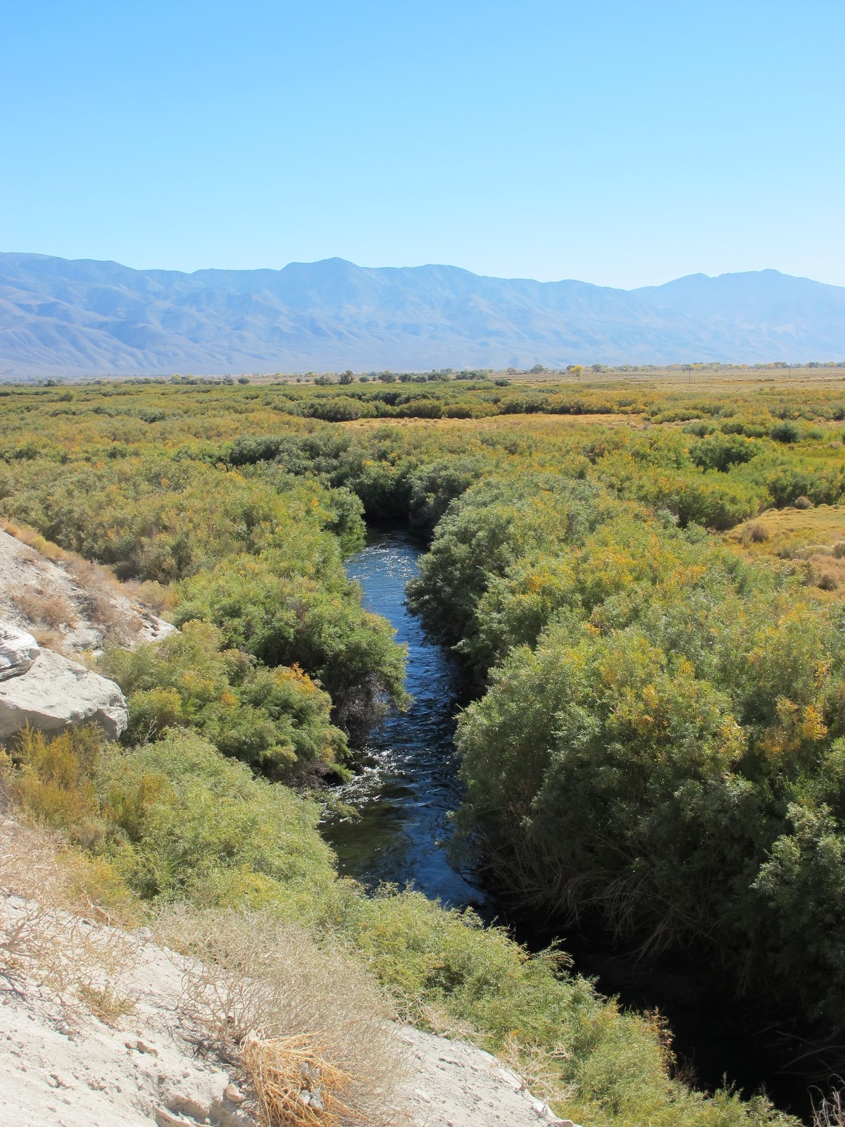
Looking down on Owens Valley and the Owens River meandering through.


Reed and David.


Mountains.


Owens Valley with the Sierras in the background. We were happy to welcome some clouds today to cool it off a bit!


Then we went into Bishop. Liza met a stranger on the road.


Lenticular clouds!! Aliens are coming, run and hide, run and hide, run and hide!!!


Sierras.


Tomorrow morning we are leaving for Vegas, it's going to be just like The Hangover!! We're camping at Lake Mead, it should be a great time. We get a new professor tomorrow, Leslie Sonder.

We won't have internet while camping, but we'll update later. That's all for now folks, see you next time.

David Adams Sinclair and Isabel Sands Caldwell

Wednesday, October 17, 2012

Fire and Ice

Howdy pardners. We are in Bishop, California in Owens Valley. It is between the Sierra Nevada Mountains on the west and the White Inyos Mountains on the east. We are staying at the White Mountain Research Center, owned by the University of California. It is really nice and we have an amazing cook, who is also a famous climber! 

Owens Valley lies around 4000 feet, on our first day here we drove up to 10,000 feet in the White Inyos Mountains. We spent the day mapping an igneous pluton. There was snow up high, and it tasted really good!


Dave and Cat getting really excited about the snow!


Rough Dog WOOF WOOF and Crab Apple mapping the pluton in the snow.


We stopped at a scenic overlook to look at the Sierras and talk about the geology. Here is Dave.


Pretty sunrise at camp, the building on the right is the cafeteria.


Kelly whipped out her sun blocking hat for the mapping days. Heh.


We spent the next two days mapping the Poleta Folds. This is a picture of our mapping area. It was really hot and sunny out both days, so Ari termed the name, Between a Rock and a Hot Place, Placenta Folds.


Joey found a friendly cactus!!!


Not so friendly after all!


Ranee and Joey taking some s's and d's (strikes and dips) and rock hammering.


Another view of our mapping area, we were above the Deep Springs Lake. It is mostly dried up.


Lots of lizards! People also saw tarantulas and rattlers. SCARY!!!


Lone Pine. We used the Dartmouth Flag so that we would know where to gather at the end of the mapping day.


Day 3: Sunrise on the Sierras.


Ranee spotted some cool clouds on our second day at Poleta.


Walking back to the vans, Dave was the flag bearer.


Today we did some roadside geology in the area, it was really pretty. This was our first stop.


Here is a roof pendant, it is where sedimentary rocks got pushed up when granite intrusions formed the Sierras. All around got eroded away. Below, there is a nice waterfall.


Trees!


We stopped at an obsidian dome, called Obsidian Dome. Here is Isabel with the obsidian. It's only 600 years old!


David on top of the obsidian.


Looking out over the Obsidian Dome.


Artsy little tree pic.


Aspen trees snaking down the mountain-side in a drainage. They are all one organism because they are connected underground. The area is covered in moraines from glaciers that came out of the mountain valleys.


Hot springs! We didn't get to swim in them but we ate our lunch up above them. A bunch of people have died there because they think they can swim in it, but it's too hot.


Pretty much all of the water from Owens Valley is sent through aqueducts to Los Angeles. LA gets the majority of its water from the Owens Valley. It dried up a bunch of lakes and a lot of plants are dying in the valley because they take the groundwater too. We just watched a film about the water going to LA and how the Owens Valley Committee is fighting to keep some of the water in the area. People have been giving Ari a lot of shit over the last few days because she is from Los Angeles!


Today we also stopped at the Owens River Gorge, with the Owens River running through. The Owens Valley used to be part of a huge volcano that erupted 600 cubic kilometers of rock and ash. The eruption formed the rocks in this canyon. Our professor, Brian, told us the area is like fire and ice because there was so much glacial and volcanic activity in the area.


Sunset at camp. We played some basketball this afternoon, it was very fun.


Here is another view of our camp.


Bubye from California,

Dave and Iz